I step out and see this:
I learned quickly that Chemtool was on fire, but was confused by which location, some were saying their Prarie Hill location and others their Rockton Rd location. -- either way a Chemical plant was on fire near my home. Rockton Rd - 4,600 ft Prarie Hill 1.5 miles (7920 feet).
At 8 am my daughter texted me this image from her work, about 1/2 mile from us, putting her 1/2 mile further from whatever location on fire asking me mom what's on fire, what's going on:
By 845 am we got our first alert from officials. It came via nixle. I years ago, not sure when, signed up for nixle and over the years included other zip codes that matter to me like my grandparents, my mom, sisters, etc. Just so I could get alerts if the local authorities used it. That nixle alert varified it was the Prarie Hill location that was on fire. It also said that those that were south of the plant had to evacuate.
This left me confused because I'm South- East of the plant and only 1.5 miles away. So I wasn't sure if that meant my household or not. Plus we had no car! Our car had been in the shop again, we had a whole mess that went along with that, that prevented us from getting a rental until that Monday morning at 11 am. So we were sitting ducks until our ride for the rental came.
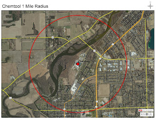
By 945 a new alert came from nixle saying that it was those within a mile from Chemtool. Well, that's was the first of many issues to come (more details later). You see that first-mile map they released looked like someone just took a sharpy and quickly drew a circle. Here is the map.
 |
| picture by Village of Rockton |
We will learn later in the week, before Thursday that this first map was drawn using the property boundaries as the 1-mile marker, it's a 200-acre property, and using the property boundaries is the reason that it's not a perfect circle radius map. -- that didn't matter Monday, what matter was I was not in the official evacuation zone, but that smoke just kept getting worst, the explosions kept happening and by the time it became noon we had our rental car, learned they were going to let it burn --stop trying to suppress it because of how close it was to the river. The winds started to shift some and I didn't feel safe. I wanted out of dodge.
I learned as far as other notifications it was broadcast on TV/Radio about 1035-11 am to evacuate and the ER broadcast system set alerts out on phones at about 11:45 am and 845 pm. Police also went door to door as much as possible, and that others were just simply notified by their neighbors.
We went to my inlaws -- hung out for several hours, listened to the 5 pm news and news conference. Talked with neighbors who stayed and because we did not have debris on our property decide to go back home Monday night. We kept our windows closed -- and stayed inside.
By Tuesday morning we learned they brought in a special fire fighting team from LA. the team dug out a trench between the fire and that river, put several absorbent booms in the river as backup, had foam they were going to put on it, and at 11 am fire suppression would start to happen. And it did. At around 11 am, after it was burning for 28 hours, we noticed the smoke plum had changed colors. We drove as close as we could get and could see they were putting stuff on the fire.
Sometime Tuesday or Wednesday a new evacuation map was circulating and being shared with the public. This new map was done with the building that was on fire as the key point, not the property boundary, and people were told that was the evacuation zone. The health department also took over the evacuation zone and said people had to stay out for health reasons because of debris and ash.
 |
| Picture by Village of Rockton |
There is more to this tale, but I feel this is enough for this post. I will make a second post soon ...
But to recap, there was a fire on Monday, June 17th. They did not start fire suppression until Tuesday morning. The evacuation map was changed -- the first used the property boundaries, the second use the building that was on fire, and there is a large 4-day music festival about to start Thursday Night. And when I say big I mean big with big-name music talent. For example this year Gabby Barret is one of the artists. It's been mostly country music over the years, but other years they have had rappers like Flo Rida.
Disclosure: This post may contain affiliate links, which means I may receive a commission if you click on a link and purchase something. See our full disclosure policy for more details.


No comments:
Post a Comment